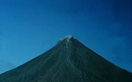
Renowned as the "perfect cone" because of its almost symmetrically conical shape, Mayon forms the northern boundary of Legazpi City. Local folklore refers to the volcano as Bulkang Magayon (Filipino: 'Magayon Volcano'), after the legendary heroine Daragang Magayon (Bikol: 'Lady Beautiful').
Mayon Volcano
Mayon Volcano lies in the eastern portion of the province of Albay and is about 300 km. southeast of Manila. Well known for its beauty and near perfect cone, this active volcano is one of the tourist attractions of the country.
Mayon reaches up to around 2,462 m. above sea level and covers an area of 250 sq. km. Its base circumference is 62.8 km. encompassing the towns of Camalig, Malilipot and Sto. Domingo.
Mayon is classified as a stratovolcano or composite cone. It consists of deposits formed basically by four major types of volcanic activity: airfall deposition, pyroclastic flows, rain triggered debris flows and lava flows. Airfalls and pyroclastic flow deposits are composed of unconsolidated materials, varying in size from ash to ssmall boulders. These deposits result from the eruption of fragmented rocks from the crater and are transported downslope under the influence of gravity, explosion blast and the prevailing wind.
Considered as the most active volcano in the Philippines, Mayon Volcano has had at least 43 eruptions since 1616. Its most violent and devastating outburst occurred on February 1, 1814. Nearby towns of Camalig, Cagsawa and Budiao were severely damaged, half of Guinobatan was ruined and at least 1,200 people perished in this eruption.
The eruptions of Mayon are usually "Vulcanian" or explosive in nature. They are characterized by the emission of fine ash and ash-laden gases forming huge "cauliflower" clouds. The symmetry of the volcano indicates that the eruptions have always occured at the central vent and that these have never been violent enough to destroy Mayon's form.
Mayon, though sometimes destructive, is also productive. Its fertile slopes and surrounding plains, coupled by abundant rainfall through the year, have made Albay a rich agricultural region with the bulk of its population found in towns bordering the volcano such as Camalig, Guinobatan, Daraga, Legaspi, Sto. Domingo, Ligao and Malilipot. The region is suited for growing abaca and coconut, two of Bicol's major crops, as well as palay and vegetables.
Mayon has the classic conical shape of a stratovolcano. It is the most active volcano in the Philippines. Since 1616, Mayon has erupted 47 times. The beautifully symmetrical Mayon volcano, which rises to 2,460 meters above the Albay Gulf, is the Philippines' most active volcano. The structurally simple volcano has steep upper slopes that average 35-40 degrees and is capped by a small summit crater. The historical eruptions of this basaltic-andesitic volcano date back to 1616 and range from Strombolian to basaltic Plinian. Eruptions occur predominately from the central conduit and have also produced lava flows that travel far down the flanks. Pyroclastic flows and mudflows have commonly swept down many of the approximately 40 ravines that radiate from the summit and have often devastated populated lowland areas.
But until today (2007) Mayon has changed its shape more and more.
NAME OF VOLCANO: MAYON
LOCATION: Albay, 300 km southeast of Manila
(13°15.4'N, 123°41.1’E)
PHYSICAL FEATURES
Elevation: 2.46 km
Base Diameter: 20 km
Base Circumference: 62.8 km (reckoned from 10-km radius) encompassing the towns of Camalig, Malilipot and Sto. Domingo
Area: 314.1 km2 (estimated from 62.8 km base circumference)
Type of Volcano: Stratovolcano
Adjacent Volcanic Edifice: Mt. Malinao, Lignon Hill and Balong Gloria Hill
GEOLOGICAL FEATURES
Rock Type: Basalt to Olivine-bearing Pyroxene Andesite
Tectonic Setting: Bicol Volcanic Chain
VOLCANIC ACTIVITY
Number of Historical Eruptions: 48
Latest Eruption/Activity:
14 July 2006 (mild eruption – quiet effusion of lava) - on going
Eruption Type:
1. Strombolian (e.g.. 1978, 1st phase of 1984 eruption)
2. Vulcanian (e.g. 1st phase of 1968 eruption, 2nd phase of 1984 eruption)
3. Plinian (e.g. 1814)
Precursors to Eruptions:
1. Increase in seismicity level (Background: 0-10 volcanic quakes per day)
2. Ground tilt due to magma intrusion.
3. Change in color of steam emission from white to gray due to entrained ash
4. Increase in the volume of steam emission
5. Crater glow due to presence of magma at or near the crater.
6. Rumbling sounds due to gas explosions, wall fracturing, landslides
VOLCANIC HAZARDS
Type of Hazards:
1. Airfall tephra
2. Lava flows
3. Pyroclastic flows
4. Lahars
Permanent Danger Zone: six (6) km radius from the summit
MONITORING ACTIVITY
Volcano Observatory: Lignon Hill Observatory (LHO) - 12 km SSE of the summit (123°43.56’ E, 13°09.64’N)
Monitoring Methods:
1. Seismic monitoring (number of volcanic quakes and tremors)
2. Ground deformation (precise leveling, electronic tilt, GPS)
3. Visual observations
4. Sulfur dioxide emission rate (by COSPEC)
5. Water well monitoring
Monitoring Stations
A - Seismic Network
· Digital Permanent: Lignon Hill Observatory, Upper Anoling, Upper Sta. Misericordia and Mayon
Rest House with repeater sites at Mt. Bariw, Upper Sto. Domingo and Tabaco
· Digital Mobile: Upper Mayon Rest House, Upper Masarawag and Lignon Hill Observatory with
repeater sites at Ligao and Camalig
· Analog: Upper Anoling
B - Ground Deformation
· Precise leveling lines: Buang Junction to Mayon Rest House (20 benchmarks); Lidong (13
benchmarks) and Anoling
· GPS stations: Legazpi (Lignon Hill), Sto. Domingo (San Andres), Malilipot (Calbayog),
Tabaco (MRH), Malinao, Ligao (Nabonton) and Camalig (Upper Anoling, Tinago, and
Palanog)
· Permanent Electronic tilt: Upper Anoling, Buang and Mayon Rest House
· Mobile electronic tilt: Upper Anoling, Lower Anoling and Upper MRHO
http://www.malapascua.de/Volcanoe-Map/Mayon__Philippines/hauptteil_mayon__philippines.htm
http://park.org/Philippines/pinatubo/page9.html
http://en.wikipedia.org/wiki/Mayon_Volcano
http://volcano.phivolcs.dost.gov.ph/update_VMEPD/Volcano/VolcanoList/mayon.htm
No comments:
Post a Comment